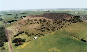
• bbq facility
  • free parking
  • free wifi
  • non smoking
  • air conditioner
  • beach view
Mount Schank

Mount Schank


Just 20 minutes south of Mount Gambier is Mount Schank, an extinct volcano rising abruptly from the plains to 158 metres above sea level. Choose from 2 steep walking trails. Both offers a great geological experience. Viewing Platform Hike - (900 metres return) begins at the car park to the crater rim and provides a different aspect to the surrounding landscape. Rock formations, including the line of small cones on the northern side.

These can be inspected more closely if driving past that area. Crater Floor Walk (1.3 km return) also begins at the car park and includes the section of the crater floor. From the top overlooking the nearby quarry, evidence can be seen of the lava flow and changes in the rock formation caused by heat and steam. On the southern side of the mountain a small cone can be seen which is believed to have been formed by the first of two main stages. A wood BBQ (BYO Wood), picnic table and toilets are provided at the base of the mountain.

mountgambiertourism.com.au

Piccaninnie Ponds

Piccaninnie Ponds


Enjoy the wildflowers in spring and the natural beauty of this unique site where the crystal clear water emerges from the underground system up through submerged caverns and underwater gardens to flow via a creek to the ocean. Walk on the board walk to the ponds, over the sand hill to the beach where the creek takes the emerging water to the ocean. Or from the beach car park, west along the established trail to view the park and creek. Take the 20 minute walk down the beach in an easterly direction to see water bubbling up through the sand.

mountgambiertourism.com.au

Princess Margaret Rose Cave

Princess Margaret Rose Cave


Enjoy an easy 20 minute circular stroll through natural bushland to spectacular views over the Glenelg River Gorge. Pack a lunch and walk 4.5 kms to Lasletts Canoe Camp taking in views of the limestone cliffs and river. See the prolific wildflowers and watch for wildlife, delicate native orchids and the many species of birds. Unfortunately it is closed at this time.

mountgambiertourism.com.au

The Great South West Walk

The Great South West Walk


A truly great walk, of approximately 250 km, has been developed and maintained by a tireless group of volunteers. Allow at least 12 days for the full walk. The Cobbononee Forest is wet from July to October and should be avoided on days of high fire danger. All other sections of the walk can be tackled any time. A free folding map is available from "The Lady Nelson" Visitor Centre and a booklet "Short Walks on and around the Great South West Walk" can be purchased by those wishing to tackle small sections at a time. Nelson Beach to Descartes Bay - 55 km of ever changing coastline with an alternative route through lightly timbered sand dunes, over Mount Richmond to Bridgewater Lakes and back to the coast. Descartes Bay to Portland - 45 km, past natural springs, grassy slopes along cliff tops.

See the petrified forest and enjoy views of Discovery Bay and Cape Bridgewater. continue through Cape Nelson State Park to Nelson Bay, past the Portland smelter into Portland. Portland to Blackwood Camp - this 20 km section follows the cliff tops, then the beach before turning inland through farmland and quiet countryside. Blackwood Camp to Moleside - approximately 60 km of changing landscape - stringy bark forest, Surry and Fitzroy Rivers with ferns and blackwoods, past the black pool known as The Inkpot to the riverside camp of Moleside. An Abundance of wildlife is present on this section of the walk. Moleside to Nelson - 45 km following the river with beautiful views of the limestone cliffs the serene Glenelg River, through Nelson Reserve, under the bridge through to Discovery Bay to complete the walk in it entirety. The wild flowers in this section are spectacular in spring Contact the Portland Visitor Information Centre on 03 5523 2671 for information on guided and specialised walks.

mountgambiertourism.com.au